[vc_row][vc_column width=”1/3″ css=”.vc_custom_1542586052458{padding-top: 5px !important;padding-left: 5px !important;}”][ultimate_spacer height=”15″ height_on_mob_landscape=”10″ height_on_mob=”4″][vc_single_image image=”15324″ img_size=”360×234″ alignment=”center” style=”vc_box_shadow_3d” onclick=”img_link_large”][/vc_column][vc_column width=”1/12″][/vc_column][vc_column width=”7/12″ offset=”vc_hidden-sm vc_hidden-xs”][ultimate_spacer height=”15″ height_on_mob_landscape=”10″ height_on_mob=”4″][vc_empty_space height=”7px”][ultimate_heading main_heading=”What is 3D Laser Scanning?” enable_heading_elem=”yes” elem_type=”side” sub_heading_letter_spacing=”3″ heading_elem_color=”#e56454″ main_heading_font_size=”desktop:36px;” sub_heading_font_size=”desktop:14px;” main_heading_style=”font-weight:bold;” sub_heading_font_family=”font_family:Libre Baskerville|font_call:Libre+Baskerville”][/ultimate_heading][vc_empty_space][vc_column_text]
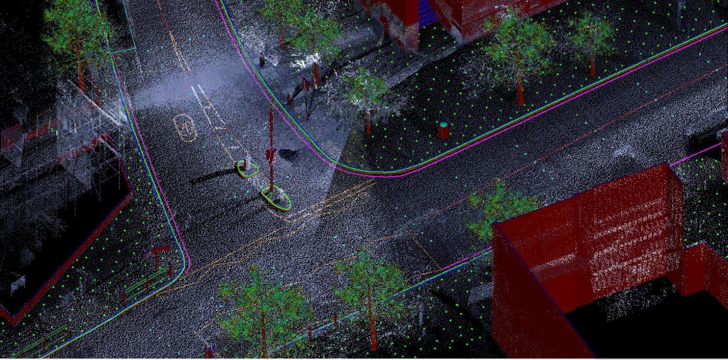
3D Laser Scanning is a relatively new, but also revolutionary, surveying technique. A laser scan yields a digital data set, also known as a “point cloud” made up of very dense points. Each point has 3-dimensional coordinates. This point cloud is then seamed together with other point clouds using control points or surfaces common to the two point clouds. This process gives the produced point cloud the same relative coordinate system. Then measurements may be taken within a CAD or GIS program using the combined and calibrated point cloud.
[/vc_column_text][vc_empty_space][/vc_column][/vc_row][vc_row bg_type=”bg_color” bg_color_value=”white”][vc_column parallax=”content-moving” css_animation=”fadeIn”][vc_empty_space height=”14px”][vc_column_text]
applications for 3d laser scanning
Remote Sensing techniques have been used for many years – aerial photography which lead to photogrammetry, reflectorless total stations, horizontal photogrammetry, and aerial lidar. 3D laser scanning is a further development of aerial lidar. It uses the same lidar technology from a ground based scanner. Therefore, the uses are different for ground based laser scanning.
Ground based can also be divided into two categories – stationary and mobile. Mobile laser scanners are mounted on some type of vehicle and driven along a route collecting data points. A stationary laser scanner is moved around an object and setup at different points to complete the capture.
Here are a few examples of uses:
Transportation Uses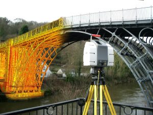
- Pavement Condition & Analysis
- Structures and Bridge Clearance Surveys
- Signage & Lighting Surveys
- Roadway/Pagement Topographic Surveys
- Engineering Topographic Surveys
- Corridor Study and Planning Surveys
- Sight Distance Analysis Surveys
- Earthwork Surveys of Stockpiles, Borrow Pits & Landslides
- Roadway & Bridge As-Built Surveys
- Railroad Surveying
- Pipeline Route Surveys
- 3D Visualizations for Presentations & Public Meetings
Land Surveying Uses
- Topographic Surveys
- As-Built Surveys
- Stockpile Volume Surveys
architectural uses
- Building Exterior Surveys

- Building Interior Surveys for Floor Planning & Documentation
- As-Built Surveys to Document Completion Percentage
- Surveys of Adjacent Buildings to Produce 3D Models of a Planned Project
- Building Information Modeling (BIM) – 3D, 4D, & 5D
- Construction Time & Cost Estimating
- Slab Flatness Surveys
- Roof Slopes & Condition Surveys
- 3D Model Creation & Presentation
miscellaneous uses
- Forensic Surveys of Accident Scenes

- Archaeology Surveying of Significant Sites
- Electric Utilities Surveys – from a safe distance & without shutdown
- Structural Analysis of Infrastructure (Towers, Buildings, Bridges, etc)
- Scanning of Complicated Piping Situations
[/vc_column_text][vc_empty_space height=”15px”][/vc_column][vc_column offset=”vc_col-lg-8 vc_col-md-8″][vc_custom_heading text=”Need expert advice? Call (844) 486-SCAN (7226) now, we’re glad to help!” font_container=”tag:h2|font_size:22px|text_align:left|color:%23000000″ use_theme_fonts=”yes” module_animation=”transition.slideLeftIn” el_class=”mobile-text-center tablet-text-center”][/vc_column][vc_column offset=”vc_col-lg-4 vc_col-md-4″][vc_empty_space height=”6px”][ult_buttons btn_title=”CONTACT US” btn_link=”url:https%3A%2F%2F3dlaserscanning.net%2Fcontact|||” btn_align=”ubtn-right” btn_size=”ubtn-custom” btn_padding_left=”20″ btn_padding_top=”10″ btn_title_color=”#ffffff” btn_bg_color=”#da5c4c” btn_bg_color_hover=”#da5c4c” icon=”Defaults-angle-right” icon_size=”24″ icon_color=”#ffffff” btn_icon_pos=”ubtn-sep-icon-left-push” btn_border_style=”solid” btn_color_border=”#da5c4c” btn_color_border_hover=”#da5c4c” btn_border_size=”1″ btn_radius=”0″ btn_font_size=”desktop:16px;” el_class=”mobile-text-center tablet-text-center” css_adv_btn=”.vc_custom_1540683167103{margin-top: 0px !important;}”][ultimate_spacer height=”0″ height_on_tabs=”0″ height_on_tabs_portrait=”15″ height_on_mob_landscape=”15″ height_on_mob=”15″][/vc_column][/vc_row][vc_row][vc_column][vc_column_text]This new technology in topographic mapping, 3D laser scanning, comes to the aid of any engineer, architect and other specialist in the field, offering the ability to access accurate data using 3D laser scanning services at any time without the need for another field visit.[/vc_column_text][ultimate_heading main_heading=”How to Make a 3D Scan of a Building” alignment=”left”][/ultimate_heading][vc_column_text]From architecture, historical monuments and archeology to buildings, transportation infrastructure, forensic and insurance surveys, the laser scanning method, with millimeter precision, allows the creation of a faithful digital copy of any building or object.
The 3D scanning process involves, in the first phase, collecting field data with a professional grade 3D scanner. The results of scanning the surface is rendered into a “point cloud” – a dense network of points that can be seen as a 3-dimensional picture where each pixel is defined with 3D coordinate points (X, Y, Z) in their natural color.
Subsequently, the digital scan made as a result of the 3D scanning process can easily be used and processed by architects, design engineers, and other specialists.[/vc_column_text][ultimate_heading main_heading=”How Does 3D Scanning Help You on Your Projects?” alignment=”left”][/ultimate_heading][vc_column_text]
- You can quickly access all the information about the 3D-scanned 2D or 3D project, 3D model, plans and sections;
- You save time without having to go to the field multiple times, and the data is to millimeter precision right from the first field visit;
- Easily process any 2D plan and solid 3D model, due to their compatibility with any CAD software;
- Analyze in detail any area without affecting the surface of the scanned object;
- With 3D scanning, the data can be taken from a wide distance range, usually up to 330 m, even under extreme or full dark conditions;
- Efficiently and accurately compute volumes;
- Get accurate and detailed as-built plans;
- Create 3D presentations and videos of any project, ideal for promoting the project and printing 3D scanned laser projects;
- You benefit from the best time / price ratio due to the efficiency of 3D data, but also because it reduces the delivery time of the architectural materials required for design.
[/vc_column_text][vc_column_text]Whether it’s 3D laser scanning of a new or old building, road construction or a historic landmark, our laser scanning team of topographers and 3D scanners ensures the correct and efficient design of any project by laser scanning in 3D.
Also, thanks to the professional equipment used by our surveyors, you will receive precise high-resolution information, which can be used in other applications. In addition, you have the opportunity to get expert advice throughout the project. For any information or details about 3D scanning, 2D or 3D models, make a request using the form below at any time and we will be delighted to speak to you.[/vc_column_text][/vc_column][/vc_row][vc_row bg_type=”bg_color” bg_color_value=”#e6e4d6″][vc_column parallax=”content-moving” css_animation=”fadeIn” css=”.vc_custom_1542584250036{background-color: #bcbcbc !important;}”][vc_empty_space height=”7px”][vc_column_text css=”.vc_custom_1542586553263{background-color: #bcbcbc !important;}”]
Terminology
Laser Scanning is also sometimes referred to also as Lidar (Light Detection and Ranging). There are really three different ways to collect the points that make up a point cloud – terrestrial, aerial, and mobile. So, you’ll often see Laser Scanning, Lidar, and 3D Scanning used interchangeably.
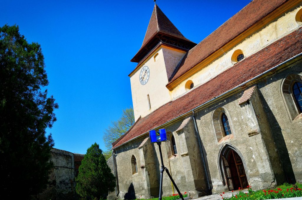
A terrestrial laser scanner sits in one position and scans as far as the sensors reach and then we move it to another location to get a different angle of the same object. This series of instrument setups are then pieced together to form one map.
We can also mount a laser scanner on a vehicle and make it “mobile laser scanning.” Placing the laser scanner in an aerial vehicle (manned or unmanned) makes it “aerial laser scanning.” Control points are important in all the different ways of collecting points. Without these precise points, the point cloud would be just a cloud related only to itself.
All of these scanning methods use ultraviolet, visible, or near infrared light to image objects. Wavelengths of the lights vary from 250 nanometers (1×10⁻⁹ m or one billionth of a meter) to 10 micrometers (1×10⁻⁶ m or one millionth of a meter).[/vc_column_text][vc_empty_space css=”.vc_custom_1542584446190{background-color: #bcbcbc !important;}”][/vc_column][/vc_row][vc_row content_placement=”middle” parallax=”content-moving” parallax_image=”10897″ bg_type=”bg_color” css=”.vc_custom_1542584041269{background-color: #c0392b !important;}” bg_color_value=”#c0392b”][vc_column parallax=”content-moving” css=”.vc_custom_1542584057790{background-color: #c0392b !important;}”][st_process_module process_module_title=”Our Process” process_content_color=”#bcbcbc” process_bg_content_color=”#c4c4c4″ process_bg_color=”#c0392b”][/st_process_module][/vc_column][/vc_row][vc_row full_height=”yes” parallax_content=”parallax_content_value”][vc_column width=”2/3″][info_list style=”hexagon” icon_color=”#dd3333″ font_size_icon=”24″ eg_br_width=”1″][info_list_item list_title=”Determine Our Clients Needs” list_icon=”Defaults-paper-plane-o send-o”]We listen to your plans for the data and help you decide on the best way to accomplish your goals.[/info_list_item][/info_list][info_list style=”hexagon” icon_color=”#dd3333″ font_size_icon=”24″ eg_br_width=”1″ connector_color=”#dd3333″][info_list_item list_title=”Planning then Data Acquisition” list_icon=”Defaults-download”]The data acquisition may be done by you or others. We can consult with you to show you how, or we can get the work done for you.[/info_list_item][/info_list][info_list style=”hexagon” icon_color=”#dd3333″ font_size_icon=”24″ eg_br_width=”1″ connector_color=”#dd3333″][info_list_item list_title=”Management of the Data” list_icon=”Defaults-database”]This includes secure storage & sharing in a safe environment.[/info_list_item][/info_list][info_list style=”hexagon” icon_color=”#dd3333″ font_size_icon=”24″ eg_br_width=”1″ connector_color=”#dd3333″][info_list_item list_title=”Assessment of the Data” list_icon=”Defaults-eye”]Insuring the data meets the project objectives and quality needed.[/info_list_item][/info_list][info_list style=”hexagon” icon_color=”#dd3333″ font_size_icon=”24″ eg_br_width=”1″ connector_color=”#dd3333″][info_list_item list_title=”Extraction from the Data” list_icon=”Defaults-image photo picture-o”]This step produces the topographic drawings or 3D models and other details needed by the client.[/info_list_item][/info_list][/vc_column][vc_column width=”1/3″][vc_empty_space height=”7px”][vc_single_image image=”15485″ img_size=”234×500″ alignment=”center”][vc_empty_space height=”7px”][/vc_column][/vc_row][vc_row][vc_column width=”2/3″][vc_custom_heading text=”Need expert advice? Call (844) 486-SCAN (7226) now, we’re glad to help!” font_container=”tag:h2|font_size:22|text_align:left|color:%23dd3333″][/vc_column][vc_column width=”1/3″][vc_empty_space height=”6px”][ult_buttons btn_title=”CONTACT US” btn_link=”url:https%3A%2F%2F3dlaserscanning.net%2Fcontact|||” btn_align=”ubtn-right” btn_size=”ubtn-custom” btn_padding_left=”20″ btn_padding_top=”10″ btn_title_color=”#ffffff” btn_bg_color=”#da5c4c” btn_bg_color_hover=”#da5c4c” icon=”Defaults-angle-right” icon_size=”24″ icon_color=”#ffffff” btn_icon_pos=”ubtn-sep-icon-left-push” btn_border_style=”solid” btn_color_border=”#da5c4c” btn_color_border_hover=”#da5c4c” btn_border_size=”1″ btn_radius=”0″ btn_font_size=”desktop:16px;” el_class=”mobile-text-center tablet-text-center” css_adv_btn=”.vc_custom_1540683167103{margin-top: 0px !important;}”][ultimate_spacer height=”0″ height_on_tabs=”0″ height_on_tabs_portrait=”15″ height_on_mob_landscape=”15″ height_on_mob=”15″][/vc_column][/vc_row][vc_row][vc_column][vc_column_text]
[/vc_column_text][/vc_column][/vc_row]